Using Multiple CRS Within the Same Product Structure | |||
| |||
-
To define geolocation coordinates for each product, click Edit
Geolocation
 from the
BIM section of the action bar.
from the
BIM section of the action bar.
You can visualize the different CRSs on products:
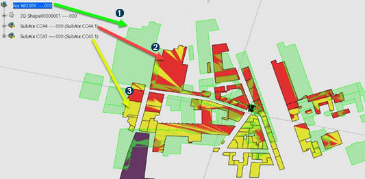
 root product with the WGS84 / World Mercator. It is rather used for larger maps.
 subproduct with the CC43 CRS
 subproduct with the CC44 CRSNote:
The image displays the same OSM (OpenStreetMap©) import in the different CRSs.
After the import into CC43 et CC44, the maps are almost at scale and they overlay properly.
The green map is the import into the WGS84 World Mercator that highlights the distortions depending on the scale factor.
-
To verify the geolocation information (including CRS) of the current product structure,
select the root product and click Geolocation B.I.
 from the BIM section of the action bar.
The Deviant B.I. status indicates that different CRSs are applied to the sites (product and subproducts).
Depending on the CRS, the geographic North may not be along the Northing (Y-axis) of a given sub-product:
CC43 and CC44 are conical projections:
Cylindrical Projection (for example Mercator) Conical Projection 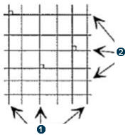
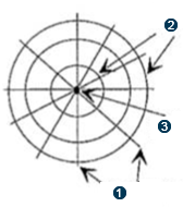 Meridians
Parallels
Pole
Meridians
Parallels
PoleA subproduct is positioned in such a way that its Northing at its geolocated origin is collinear with the Northing vector of the containing product at the same geographic position.
-
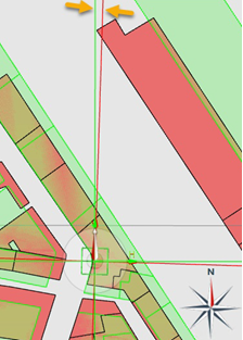
To display the discrepancy between two CRSs, zoom in on a zone.
You may notice a gap between both maps, between CC43 and CC44 CRSs.


Different CRSs do not have the same position because their scale is different. However directions remain parallel between different CRSs.
Important: It is important to think about the area of use before shifting from one CRS to another. Ensure that the CRS of a containing product is compatible with the contained product.
You can use different CRSs: different maps overlap in some areas when you work in the same 3D Shape. But you must keep in mind that the projection axis may vary by a few centimeters and deviate from reality.
-
To know the coordinates of a point within the 3D model, change the source CRS values by
selecting a zone in the 3D area and
clicking Coordinate Converter
 .
.
You indicate the picked position in the CRS which is defined in the product containing the picked object.
The source changes according to the CRS assigned to the product or subproduct.
-
To update the whole structure, click Update All
 .
.
The product position can be computed even if an upper element within the product structure is using a different CRS.
The update of a product with multiple CRS referenced in its structure is possible.