About Geometry Validation | |||
| |||
QGIS offers a diagnosis tool that may help to understand which geometries are to be considered as valid or not. In that case, the “GEOS” method of QGIS diagnosis tool is preferred to be consistent with both OGC and City apps.
OGC rules for simple feature datasets are as follows:
- A line is simple if it does not pass through the same point twice (with the possible
exception of the two end points).
City apps and Globe service support both simple and non-simple lines.
- For information about rules that define valid polygons, refer to https://portal.opengeospatial.org/files/?artifact_id=829.Note: The "Two Rings" condition means that at a point common to two curves, nearby points cannot be common. This forces each common point to be a point of tangency.
Lines are supported as simple and non-simple drawings, closed or not:
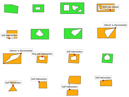
Polygons might have particular cases that make them difficult to define a contiguous area, especially when they contain holes.
In the example below:

- Polygons in green are valid and functional in City apps. They are counted in the statistics of the global number of features and are displayed on the map, in the Properties panel, and in the City Attribute Table.
- Polygons in orange are potentially invalid as a single instance of a polygon. The red
dots represent the error location when considering the outline as a polygon.
These polygons are neither counted, nor displayed in City apps. For multi-polygons containing at least one invalid polygon, the feature as a whole is considered as invalid.
Therefore, the number of processed geometries might differ depending on the nomber of valid and invalid polygons.