-
From the Tools section of the action bar,
click Measure Distance
 . .
-
In the
Measure Units panel, select the appropriate unit
system.
- Metric system also known as the
"International System of Units (SI)" which is the international decimal system
of weights and measures. The following units are used:
| Unit
|
Abbreviation
|
| Millimeter
|
mm
|
| Meter
|
m
|
| Kilometer
|
km
|
| Square meter
|
m2
|
| Square kilometer
|
km2
|
| Hectare
|
ha
|
- Imperial system for units defined in the
British Weights and Measures Act of 1824. The following units are used:
| Unit
|
Abbreviation
|
| Inch
|
in
|
| Foot
|
ft
|
| Yard
|
yd
|
| Mile
|
mi
|
| Square inch
|
sqin
|
| Square foot
|
sqft
|
| Square mile
|
sqmi
|
| Acre
|
ac
|
The selected unit is saved in the browser local storage associated with
the platform URL. This means that you retrieve the selected unit on any
dashboard containing a City widget, provided that you use the same computer,
the same Windows account, the same web browser, and that you have not cleared
internal app settings.
Units are adaptive: when measuring at small scale, the units are "feet"
and "meters", while changing the points to larger distances, the units will
adapt to "miles" or "kilometers" (depending on the chosen metric system).
-
Click a start point and an end point.
The distance between the two clicked points is displayed. 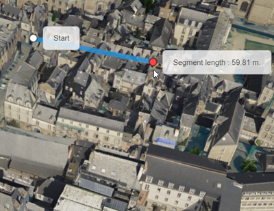
-
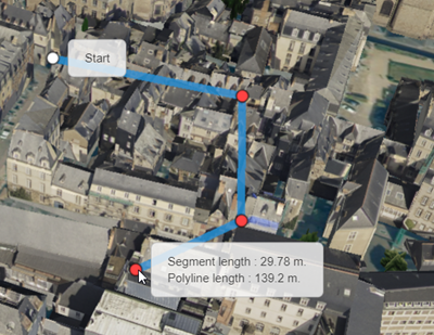
Click several points successively.
Each click displays the distance from the previous point in the polyline. The
cumulative total distance from the start point along the polyline is also displayed.
-
To display a previous intermediate result, move your mouse over the point of your
choice with the cursor.
-
To remove a point from the polyline, click it.
-
Click Measure Distance
to exit the command.
All points are deselected.
|
