You can display a gradient on the ground to indicate the slopes, orientation, and
elevation of the terrain.
Before you begin: This functionality is relevant for raster terrains only, not for
geometric terrains.
From the
Tools section of the
action bar,
click
Terrain Analyzer.
In the
Terrain Analyzer panel, select the rendering
mode.
Pixels are colored with respect to the color scale. This scale is divided into
segments of color, and each color segment is assigned a range of values on the
scale.
Mode
Description
Elevation
Displays a color for each pixel depending
on its elevation (Z coordinate).
Every pixel with an elevation lower than the
minimum height has the lowest color value.
Every pixel with an elevation higher than the
maximum height has the highest color value.
The lower and upper bound are defined by the minimum
and maximum height. In this mode, the minimum and
maximum heights are automatically computed according to
the terrain dataset.
The gradient is a continuous
progression between a minimum and a maximum value.
Slope
Defines the angle of inclination of the
terrain.
Each pixel is colored depending on its vertical
angle. A horizontal plane has the lowest color value,
whereas a vertical cliff has the highest color.
The gradient is a continuous progression between
a minimum and a maximum value.
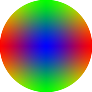
Orientation
Colors each pixel depending on its facing
direction.
The three color components (RGB) represent the
coordinates of the facing orientation (X,Y,Z).
Therefore, a horizontal plane will be more blue, a
north- or south-facing terrain will be more green,
whereas an east- or west-facing terrain will be more
red.
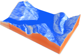
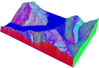
When in
Elevation mode, adjust the minimum and maximum
heights to point out zones of interest on your map.
Elevation 1. Default values are kept when the terrain analyzer is run.
Elevation 2. Minimum and maximum heights are modified.
Important:
Customized values are stored in the experience
and persist across sessions.
Click
Reset to default value to restore the default values computed from the terrain
dataset.
 .
.


 to restore the default values computed from the terrain
dataset.
to restore the default values computed from the terrain
dataset.