What's New | ||
| ||
R2022x FD01 (FP.2205)
- The rendering of all layers now uses Dassault Systèmes' Physically Based Rendering (PBR) standards to improve realism and consistency. Thus, the rendering of light, shades and shadows has been improved in your experience:
- Projected shadows are more accurate and consistent when cast on the ground and items.
- The sky image you select now impacts the general lighting of your experience.
- A new preference to restore performance profile.
- Screen-Space Local Reflections makes windows and water reflect their urban environnment.

- You can now use
 Create Building and
  Create House to sketch houses and buildings in your
experience.
Create House to sketch houses and buildings in your
experience. - Before sketching the house or building, you can add a visual bookmark on a
given area to indicate that you plan to sketch a house or a building here. After you
sketch the house or building, you can:
- Move the sketched house or building using the Robot.
- Specify the number of floors of the sketched house or building.
- Specify the height of the sketched house or building.

- You can now:
- You can now:
- Filter and sort the list of datasets in the referential.
- Show or hide additional columns to display more information about your datasets.
- Change the size of the columns, or pin them.
- Perform a search to highlight certain words or numbers in the Referential panel.

- You can now preview datasets under the
.kml,.zgbd,.gml, or.csvformats in your experience. - After you upload a file with one of the extensions mentioned above in 3DSpace or
3DDrive, you can drag the file to preview its content directly in your experience. A
Temporary Items node appears in your tree with the previewed content.
The gif below illustrates the dragging of a
.gmlfile from 3DDrive to an experience.
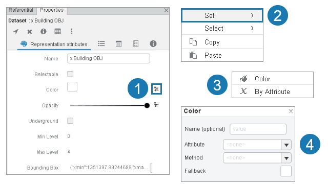
- For simple styles or styles based on attribute, you can now:
-
- Create and save many styles on a dataset.
- Transfer styles from one dataset to another dataset.
The image below shows you the steps to create styles.
Light, Shades and Shadows
Benefits: Your experience is more realistic and consistent.
For more information, see
Defining Rendering Modes
Sketch Houses and Buildings
Benefits: You can sketch and manipulate custom buildings and houses.
Improve Authoring Capabilities
Benefits: You can track the progress of an upload and share edited, duplicated, or moved
items with others.
Customize the Referential Panel
Benefits: You can display only the datasets or information that are of
interest.
For more information, see
Working with the Referential Panel
Preview Datasets of Different Formats
Benefits: You can verify the output if you add the datasets to your experience before
needing to upload them in City Referential first.
For more information, see
About Datasets
Create and Transfer Styles on Datasets
Benefits: One layer of dataset can have many styles that you can transfer on other
datasets without needing to create the styles manually.
For more information, see
Managing Styles on a Dataset to Define its Color
R2022x GA
- You can now drag the GIS files stored in 3DDrive and drop them into the 3D view for direct preview. You can also explore GIS files uploaded in 3DSpace in preview mode without any indexation delay.
- Project space, task, and issues originated from 3DSpace can now be geolocated in City experiences. You can now get these objects from the referential to enable project management from the City viewer, and reopen them from a relevant app.
- An additional tool improves collaboration with a 3DSwym content-oriented annotation from the City 3D view. Such 3DSwym content is made available in City as a specific type of annotation. In 3DSwym, the generated content contains a new type of map link that retrieves the related City experience in a transient widget.
- The layout of the Properties panel has been improved to display additional information, and provides a quicker access to each section.
- Extended support of drag-and-drop capabilities to improve exchanging city objects with other 3DDashboard apps.
- The City Attribute Table can now display items loaded using the new capabilities of the GIS preview, including 3DDrive, for a better consistency in cross-highlight.
- The Information panel now includes a new geolocation method for a raw coordinate or an address on the map. This method involves both geocoding and reverse geocoding enhancements.
Preview of GIS Files Stored in 3DDrive and 3DSpace
Benefits: GIS files uploaded in 3DSpace and 3DDrive can now be explored instantaneously in City Discover.
Extended Geolocation
Benefits: Optimizes project management in City related projects by enabling geolocation
of3DSpace objects and displaying an icon for them in City. You can review these objects and
open them from the City map displayed in City apps.
Specific Annotation for Creating 3DSwym-oriented Content in the City 3D View
Benefits: Provides the capability to create 3DSwym objects, and review them in City.
Properties Panel Reorganization
Benefits: You can better access dataset properties in City Discover
Support of Drag-and-Drop Interactions
Benefits: Standard interactions across City apps for
list and grid view UI-related components
harmonized with other apps.
City Attribute Table - Extended Display Content
Benefits: A consistent cross-highlight between items displayed in the City Attribute
Table and 3DDrive.
Information Panel - Enhanced Geocoding and Reverse Geocoding
Benefits: Enables you to search a location on a map using a single address, coordinates,
or both.