About Format Files | ||
| ||
The terrain files you can import can be any of the supported formats:
- ASCII RGB
- ASCII User Format
- ASCII free
- Cgo
- GoCad (surfaces)
- SRTM
- Stl
- LIDAR
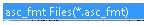
The table below lists the available import formats, the supported file extensions, and provides the type feature that can be imported.
| Format | File extension | Type of features |
|---|---|---|
| ASCII RGB |
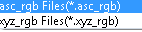 |
cloud of points |
| ASCII User Format |
 |
cloud of points |
| ASCII free |
 |
cloud of points |
| Cgo |
 |
cloud of points |
| GoCad (surfaces)* |
 |
mesh |
| LIDAR |
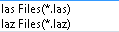 |
cloud of points |
| Srtm* |
 |
mesh |
| Stl (including ASCII and binary)* |
 |
mesh |
| * For these three formats, you can create a cloud of points by clearing the Create Facets check box. | ||