Colorizing a Terrain

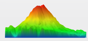
Colorizing a terrain mesh consists of applying a color code to each point of the terrain mesh with respect to elevation—geometric height.


Before you begin: The optimized display mode must be enabled in Me > Preferences.
See Also
About Terrain Preparation
  1. From the Prepare section of the action bar, click Colorize by Height Map .
  2. Select a terrain mesh.

    The color shading is automatically applied according to the surface elevation from the minimum height value identified in blue up to the maximum height value identified in red. These values are called represented by rated points.
    Note: You can select multiple elements at a time, the elevation of the selection set is accounted for in the calculation.
  3. Deactivate the color height map:
    1. In the tree, right-click the height map and select Properties. Alternatively, right-click the height-map.
    2. In the Display Modes tab, clear the colored check box in the Point area.