Identifying a CRS and Importing it

Defining a reference system (CRS) for a project consists of identifying the CRS to be used for the project .

To help you find the reference information you need to use the content delivered along with your app, you can consult the 3DEXPERIENCE Native Apps Content.

This task shows you how to:


Before you begin:
  • You or your administrator must have installed the app content. For more information, see Native Apps Installation: Installing Native Apps.
  • Prior to specifying a coordinate reference system for a collaborative space, import it from a resource directory in the3DEXPERIENCE install folder: \win_b64\resources\geolocation and unzip the appropriate .zip file.
The app optional content is not automatically installed along with the code. Contact your administrator if you must install the files you need. For more information, see Install Optional Content. You can also see Installation and Setup:Install: 3DEXPERIENCE Platform: Installing 3DEXPERIENCE Platform Services for the First Time: Installing Services One-by-One: Native Apps: Installing Native Apps: Installing a Native App.

Quick Start Procedure

If you know the CRS code to be used for a collaborative space, start by searching it in the CRS 3DXML resources provided along with Building and Civil Assemblies.

  1. Select the EPSG-8.5.3-CRS-3dxml.zip which is located in \win_b64\resources\geolocation.
  2. Extract the .3dxml file that contains the CRS of interest. All CRS resources provided with Building and Civil Assemblies originate from the online EPSG registry.
  3. Log in to 3DEXPERIENCE with the Leader role.
  4. From the Compass, click Social and Collaborative Apps , and select Data Setup.
  5. As a geomatician, you are granted the Leader role and can Import the CRS resource file. To do so, select Add > Import > 3D XML... and select the desired 3D XML file.
  6. In the Import Option area of the dialog box, select Import As Ref.

    Note: For full instructions, see Exchange Management User's Guide: Import 3D XML: Importing 3D XML Files.

    The CRS 3D XML resource file is imported into the database.
  7. Alternatively, log out and log in again with the Owner role.

  8. Log out from 3DEXPERIENCE.
  9. Log in again to benefit from the Data Setup modifications.
Identify a CRS

If you know the code but could not find it in the samples or if you do not know the CRS code to be used for a collaborative space, search for it in the EPSG registry.

  1. Go to the online EPSG Geodetic Parameter Dataset registry (http://www.epsg-registry.org/).
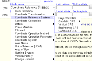
  2. In the Type box, select Coordinate Reference System.
  3. Select a type of CRS to narrow the search:
    • Projected CRS
    • Geodetic CRS
    • Vertical CRS
    • Engineering CRS
    • Compound CRS


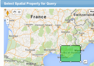
  4. Click Show Map to accurately determine the zone of interest.
  5. Click the rectangle in the map to define a zone.

  6. Close the map.
    The coordinates values are updated accordingly:

  7. Click Search.
    The list of matching CRS's is displayed.
  8. Select the required CRS code and search for it in the provided CRS 3DXML resources. See Quick Start Procedure.