Content of the Report
The report consists of detailed alignment information that are displayed in a table. The information is exported to an output XML file.
The report can be a .html file or an .xls file that consists of the summary and details of a single created alignment. An alignment report is generated based on the date and time. Generating a new report overwrite the previous one. If you modify an alignment, for which a report was created you must generate a new report to account for the modifications. The report displays the following information under specific nodes:
- Position including stationing values
- Geolocated position
- Cumulative distance: The cumulative distance along alignment from start station
- Distance: The distance from previous point
- Elevation: The Z elevation of the point.
- Terrain elevation: The Z elevation of the terrain at this point (only if terrain curve has been selected, else 0).
- Difference elevation: The elevation difference between the point and the terrain. If positive it is embankment (fill) else if it is negative it is excavation (cut).
- Horizontal alignment geometry types and parameters: Alignment lines and curves: types of geometry (line, arc, transition) on horizontal alignment along with geometrical parameters values such as length and radius
- Vertical alignment geometry types and parameters
- Slopes and gradients: Types of geometry on vertical alignment (line, arc) on vertical alignment along with geometrical parameters values such as gradient (in case of line type) and radius.

 : The vertical alignment curve
 : The reference terrain curve (if previously selected)
 : Vertical reference lines on each characteristic point:
stations from horizontal alignment and transition points between geometries on
vertical alignment.
: Vertical reference lines on each characteristic point:
stations from horizontal alignment and transition points between geometries on
vertical alignment.
 : The alignment table
 and
and
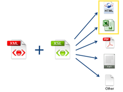
 functions are based on the XSL technology. HTML and Excel
formats are provided along with
functions are based on the XSL technology. HTML and Excel
formats are provided along with